As the now-notorious Chinese spy balloon was slowly making its way across the sky of central Missouri in early February, it was being shadowed by an American U-2 spy plane, the federal government …
This item is available in full to subscribers.
We have recently launched a new and improved website. To continue reading, you will need to either log into your subscriber account, or purchase a new subscription.
If you are a digital subscriber with an active subscription, or you are a print subscriber who had access to our previous wesbite, then you already have an account here. Just reset your password if you have not yet logged in to your account on this new site.
If you are a current print subscriber and did not have a user account on our previous website, you can set up a free website account by clicking here.
Otherwise, click here to view your options for subscribing.
Please log in to continue |


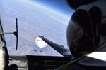
As the now-notorious Chinese spy balloon was slowly making its way across the sky of central Missouri in early February, it was being shadowed by an American U-2 spy plane, the federal government confirmed to national media outlets last week.
That information came to light last week when the government released a selfie photo taken by the pilot of the plane, looking down on the balloon from above. The Pentagon declined to provide an exact location of the photo, but a reporter with NPR (National Public Radio) has used information from the photo itself to place the balloon and plane just south of Bellflower in Montgomery County at the time the photo was taken.
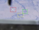
NPR science correspondent Geoff Brumfiel described the process of pinning the photo to a specific location in a lengthy Twitter thread on Feb. 23. Using details from the high-resolution photo, combined with satellite imaging tools, Brumfiel traced a line of distinctive geographic features in order to identify a tiny town at the bottom-left of the photo. That turned out to be Bellflower, which is located in Montgomery County, about 20 minutes north of Jonesburg.
First, Brumfiel identified the most prominent geographic feature in the photo: the Mississippi River. More specifically, he identified the river’s lock and dam at Clarksville. Then, he identified a distinctive bend on U.S. Highway 61 that is roughly in line between the town in the photo and the dam.
Tracing that line on a map, Bellflower stood out as a candidate for the town, Brumfiel said. Sure enough, details from the photo exactly matched the shape of wooded areas and tree lines around the town, as well as a reservoir in town and an agriculture supply business to the north.
One other interesting detail from the photo: The shadow of the U-2 plane is visible on the balloon, allowing observers to estimate the diameter of the balloon to be about 130 feet. That matches a size estimate previously provided by the federal government.
The entire Twitter thread about pinpointing the photo's location can be viewed at this link.